Trip Details

  • Destination: Nepal
  • Trip Difficulty: Very Strenuous
  • Trip Style: Camping Trek
  • Transport: Private Vehicle & Flight
  • Food: Breakfast, Lunch & Dinner
  • Accommodation: Lodge & Camping
  • Group Size: 16
  • Max Elevation: Kagmara Pass (5115m)

Highlights

  • Enjoy the scenic mountain flight to and from Juphal
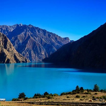
  • The stunning view of the Phoksundo Lake
  • Challenging Numa la and Baga la passes
  • Widespread diversity of flora and fauna
  • Breathtaking views of the snowy peaks
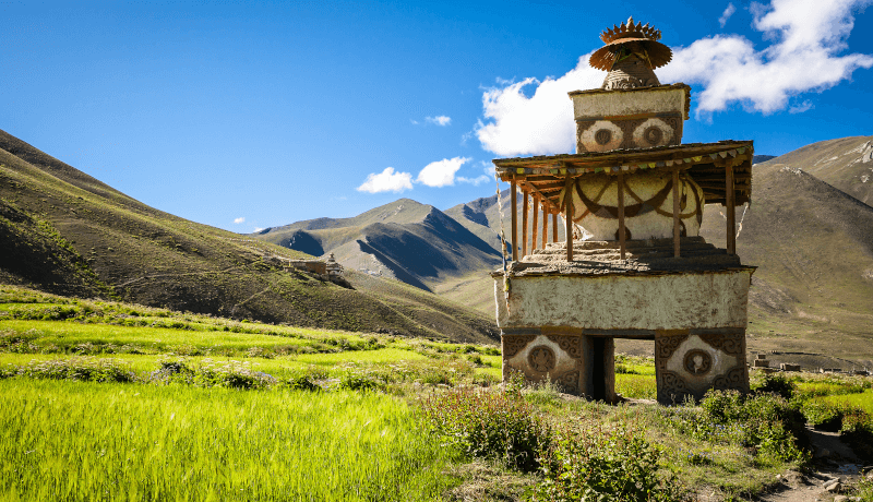
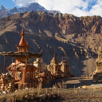
  • Ancient villages and isolated monasteries
  • Enchanting Buddhist culture and traditions
  • Observation of the remoteness of Nepal
     

Description

Lower Dolpo Circuit Trek is considered to be one of the most remote trekking destinations in Nepal. Lower Dolpo is a camping trek that goes into the mesmerizing nature and people living a very basic life in the hills of Dolpa. 

Lower Dolpo Trekking is an adventurous journey to the far west region in Nepal. This trek was opened for foreigners in 1982. It is a journey that will take you to one of the hidden parts of the Himalayas. Only a handful of people get to visit this region. The ancient culture and raw nature of the region will rejuvenate your soul. The bright glistening Phoksundo Lake,  panoramic Himalayan mountains, blue sky, thrilling terrain, and isolated villages enhances the journey.

Likewise, you will get an opportunity to know more about the people of Dolpo and ancient Tibetan Buddhism they follow. The people follow this Pre Buddhist religion Bon- Po due to its nearness to the Tibetian border. 

The lower Dolpo trek starts with air-flight from Kathmandu to Nepalgunj ending at the traditional Juphal village. Juphal village is the entry point to the Dolpo region. Passing through the farming lands, rusty roads, and traditional villages you will cross Chanla Pass and the trek towards Numala Base Camp. Enjoying the beautiful Kanjiroba massif you go through Bagala pass and reach the Phoksundo region. After reaching the Phoksundo Lake region, you will get on board on nearby lodges and rest for the day. 

Later you will do the sightseeing at Shey Phoksundo Lake and follow the trekking trail towards Pungmo village. Passing the village you will walk towards the Kagmara High Camp and cross Kagmara Pass. Walking past the Kagmara Phedi, you reach Toijum. You will follow the trekking trail of the Kaigaon village and reach Chaurikot. It is located at 3700m. Then you will finally descend your way towards Jumla Khalanga Bazaar. From Jumla, you will take a flight to Nepalgunj and take a flight to Kathmandu.

Note: You can also extend the trek as your schedule. This is the full itinerary of Lower Dolpo Trek. We can change the routes according to your choices. Mount Mania provides you with a complete plan of your trek and takes you through a hassle-free journey. For further inquiries, contact us.
 

25 Days Lower Dolpo Circuit Trek Itinerary

Expand AllHide All

Today is the day when our Lower Dolpo Trek starts. On our first day, we fly to the western side of Nepal. It is about a 1-hour flight from Kathmandu to Nepalgunj. Nepalgunj lies nearby the Nepal-India border. Nepalgunj offers you the taste of both Hindu and Muslim cultures. Overnight at our hotel inclusive full board meals.

  • Meals: Lunch & Dinner
  • Accommodation: Hotel
  • Altitude: 150m

On this day, we will catch another flight to reach Juphal. It takes about 45 minutes to reach Juphal with a scenic view of mountains. Our trekking crew will receive you at the airport on your arrival to Juphal.

Our first day on the trail begins with an hour of downhill hiking through the Juphal village. Then leading through the terraced fields to the Bheri River taking 2-3 hours we reach Dunai. Overnight at Dunai.

  • Meals: Breakfast, Lunch & Dinner
  • Accommodation: Camping
  • Altitude: 2020m

In today's trek, we walk past many small streams and then follow the Bheri and Barbung river. The river runs through a tremendous gorge with pine trees and an ingenious path built about seven meters above the river. After walking for some time we come to Tarakot where colorful terraced fields greet us. We will camp by the river about 150m below the village, near the police post. Overnight at Tarakot with all meals inclusive.

  • Meals: Breakfast, Lunch & Dinner
  • Accommodation: Camping
  • Altitude: 2537m

On this day we follow the trail on the southern bank of Bheri River that leads us to Tarakot. Tarakot is an open valley from where we trek to Musi Khola. Musi Khola is located at an altitude of 2875m. We camp for the night at a large meadow in Musi Khola.

  • Meals: Breakfast, Lunch & Dinner
  • Accommodation: Camping
  • Altitude: 2875m

From Musi Kharka we trek for about 6 to 7 hours and reach the village of Karkot. Karkot is a small village located at an altitude of 3200m. You will get to explore the beautiful scenery along the way to Karkot village. Overnight in Karkot village. 

  • Meals: Breakfast, Lunch & Dinner
  • Accommodation: Camping
  • Altitude: 3200m

Early in the morning, we start our journey from Karkot towards Pimari Village. Pimari village is located at an altitude of 3941m. You will walk for around 5 hours to reach the village. After you reach the village you will spend the rest of the day exploring the Pimari village. Overnight at Pimari Village. 

  • Meals: Breakfast, Lunch & Dinner
  • Accommodation: Camping
  • Altitude: 3941m

Today we pass through forests of birch, pine, and juniper to reach Shabha Kharka. After going through the amazing scenery and walking for 5 to 6 hours we reach Shabha Kharka. Overnight in Shabha Kharka.

  • Meals: Breakfast, Lunch & Dinner
  • Accommodation: Camping

On this day we make our way towards Papta Chanla Base Camp from Shabha Kharka. It takes about 6 hours from Shabha Kharka. Walking through trails we make an arduous trek to Papta Chanla Base Camp. Camping in Papta Chanla BC for the night.

  • Meals: Breakfast, Lunch & Dinner
  • Accommodation: Camping
  • Altitude: 4500m

Today we come across several villages while walking along the bank of Tarap Khola. We pass many mani walls,chortens, monasteries, prayer flags fluttering in the breeze. Local people are very close to the Tibetan lifestyle. We cross the Chanla pass located at 5200m and reach Dho Takyo village. Dho Takyo is the uppermost village of the Tarap region. Overnight at Dho Takyo village. 

  • Meals: Breakfast, Lunch & Dinner
  • Accommodation: Camping
  • Altitude: 4080m

Dho Takyo is a Gurung village located at an altitude of 4080m. This village is rich in Buddhist culture. We explore the beautiful monasteries, chortens, mani walls, and prayer flags on this day. It is worth visiting all the gompas. It is the largest settlement in Tarap. The main attraction in this village is the Ri Bhunpa Gompa and the Chorten within a Chorten. We will take a nature tour. Overnight on Dho Takyo village.

  • Meals: Breakfast, Lunch & Dinner
  • Accommodation: Camping
  • Altitude: 4080m

Early in the morning, we trek through an arid country with wonderful eroded pillars. If the weather is clear you can see the views of Dhaulagiri massif. We trek along the steep ascent path until you reach the Numala base camp. Numala Base Camp is located at 4350m. Overnight at Numala Base Camp.

  • Meals: Breakfast, Lunch & Dinner
  • Accommodation: Camping
  • Altitude: 4350m

On this day we cross Numala Pass located at 5190m and descend towards Poyon Khola till we reach Bagala Base Camp. Bagala Base camp is surrounded by big glaciers and blade-shaped rock cliffs. We stop for the night at Danigar located at 4513m. This place is surrounded by hills with temporary houses, yak pasture, and terraces. You can see Topo Peak (4900m) in the panorama for the first time. While the Norbukang Himal sparkles at the back. 

  • Meals: Breakfast, Lunch & Dinner
  • Accommodation: Camping
  • Altitude: 4513m

We make our way to Yak Kharka crossing Bagala Pass located at 5070m. We get to enjoy the beautiful view of Kanjiroba massif from the pass. The trails turn gentle after Bagala Pass and descend all the way to Yak Kharka. Yak Kharka is located at 3995m and you need to walk around 6 hours to reach there. It is an open grassland and grazing grounds for yaks and sheep. Overnight in Yak Kharka. 

  • Meals: Breakfast, Lunch & Dinner
  • Accommodation: Camping
  • Altitude: 3995m

Today we trek to Phoksundo Lake located at 3610m via Ringmo. It takes about 7 hours to reach Phoksundo lake from Yak Kharka. The trail goes downhill from Yak Kharka till Ringmo. Ringmo is a small village where Gurung and Thakuri communities reside. We move along the flat land passing through hills, grassland, pine forests, terraces, and villages.

As we move forward the views of Phoksundo Lake appear before us. We reach our destination after crossing a wooden bridge.

Phoksundo Lake is known as the deepest lake in the world. Most people of the big village lying at the bank of this lake follows Buddhist culture. There are monasteries, chortens, prayer flags, mani walls, shops, hotels, lodges, terraces and so on. This village is beautifully surrounded by hills.

  • Meals: Breakfast, Lunch & Dinner
  • Accommodation: Camping
  • Altitude: 3610m

Today we explore magnificent Phoksundo Lake and the area around it. The lake is famous for its spectacular scenery and its magnificent turquoise color. Ringmo village looks like a typical Tibetan village, is scenically nestled in the area. You can find many beautiful glaciers above the lake area. There are many monasteries and Bon-po religious sites at the park and we spend our time visiting some of these. We will explore natural sites and enjoy our nature tour.

  • Meals: Breakfast, Lunch & Dinner
  • Accommodation: Camping
  • Altitude: 3610m

Early in the morning, we follow a trail that stays high above the stream to Pungmo Khola. The route enters birch and juniper forests. We get to see the views of the Kanjiroba peak in the horizon above the barley fields of Pungmo village. It is a fortress-like village located at an altitude of 3500m. Overnight at Pugmo Village.

  • Meals: Breakfast, Lunch & Dinner
  • Accommodation: Camping
  • Altitude: 3500m

On this day we start our trek from Pungmo village. We take the route on the side of the Pungmo Khola and ascend towards Kagmara high camp. Walking for about 6 hours and going through pass forests and blue pine trees we reach Kagmara High Camp. It is located at 4800m and is our camping destination for the night.

  • Meals: Breakfast, Lunch & Dinner
  • Accommodation: Camping
  • Altitude: 4800m

On this day we climb alongside the Kagmara Glacier to the Kagmara La pass at 5115m. The panoramic views of the peaks are incredible. People here lead a primitive life, yet they are friendly. We will also get to explore the wildflowers and exotic birds on your way to Kagmara Phedi. Overnight at Kagmara Phedi.

  • Meals: Breakfast, Lunch & Dinner
  • Accommodation: Camping
  • Altitude: 4190m

From Kagmara Phedi we trek to Toijum which is located at 2920m. We cross a series of waterfalls and descend from the hill until we reach Garpung Khola. From here the Toijum village is just nearby. We camp near the army post.

  • Meals: Breakfast, Lunch & Dinner
  • Accommodation: Camping
  • Altitude: 2920m

On the following day, you will leave Toijum and then move forward to Kaigaon. It is situated at an elevation of 2650m and takes 5 to 6 hours from Toijum. It is one of the most beautiful villages that you will encounter so far. You will get to explore several villages of mixed culture along the route. Stay overnight in a tented camp at Kaigaon.

  • Meals: Breakfast, Lunch & Dinner
  • Accommodation: Camping
  • Altitude: 2650m

On this day we will start out trek from Kaigaon village to Chaurikot. We go through a fairly gentle trail today. We climb on a grassy hill for a panoramic view to the distant Dhaulagiri Himal. We reach Chaurikot which is located at 3700m. Camp for the night at Chaurikot.

  • Meals: Breakfast, Lunch & Dinner
  • Accommodation: Camping
  • Altitude: 3700m

Early in the morning, we trek from Chaurikot to Chotra. Chotra lies at a distance beyond Chaurikot and is located at 3380m. Khampas people from eastern Tibet who are traditionally Buddhists are the inhabitants of Chotra. It is also the home of Matwali Chettries. Their religious practices have very little to do with Hinduism. Their rites are conducted by shamans known as Dhami or Jhankris. Overnight at Chotra. 

  • Meals: Breakfast, Lunch & Dinner
  • Accommodation: Camping
  • Altitude: 3380m

From Chotra we trek to Ghotichaur which is located at 2650m. On this day we trek through completely flat land. You can see pass forests, terraces, and villages situated at the bank of the river. There are some 13th century Malla dynasty stone carvings at the spring here. This place is completely surrounded by pine forests and has a sheep farm nearby. Overnight at Gothichaur.

  • Meals: Breakfast, Lunch & Dinner
  • Accommodation: Camping
  • Altitude: 2650m

We trek from Gothi Chaur to Jumla. The trails we follow is a steep ascent up to Pattyata Lagna Pass. We pass Dochar Gara and follow the flat route to Gariakot to reach Jumla. This is a small village with a terrace, apple orchard, beautiful green hills and it lies at the bank of Tila Khola. We reach Jumla late in the evening and stay there for the night.

  • Meals: Breakfast, Lunch & Dinner
  • Accommodation: Camping
  • Altitude: 2540m

We will take a flight from Jumla to Nepalgunj. Arriving in Nepalgunj you will fly to Kathmandu airport. The one-hour long flight is scenic. It is interesting to observe the aerial view of the Kathmandu valley getting denser and denser.

After landing in Kathmandu, we will escort you to your hotel in a private vehicle. Overnight in Kathmandu. We will serve you farewell dinner on this day.

  • Meals: Breakfast
  • Altitude: 1320m

What to Expect

Cost Includes

  • Airport Pickup and Drop (Domestic Terminal)
  • Camping and Teahouse accommodation during the trek
  • Three meals a day (Breakfast, Lunch, and Dinner) during the trek
  • Round Trip Flight Ticket (Kathmandu, Nepalgunj)
  • Flight Ticket (Nepalgung, Juphal)
  • Flight Ticket (Jumla, Nepalgung)
  • English Speaking Trekking Guide with Insurance, Transportation, Food and Accommodation
  • Porter with Insurance, Transportation, Food, and Accommodation
  • Cooking Staff and Helper 
  • All Camping equipment like Tents and Kitchen equipment
  • All Necessary Trekking Permits (Upper Dolpo Special Permit, Shey Phoksundo National Park)
  • Use of sleeping bag & Duffel bag (if you don’t have your own, To be return after trip completed)
  • Daily seasonal fresh fruits after dinner 
  • A first aid kit carried by the guide (Oximeter to measure your oxygen and pulse in high altitude) 
  • All Government and Local taxes

Cost Excludes

  • International Flight Ticket and Nepalese Visa Fee
  • Hotel & Meals in Kathmandu
  • Extra night accommodation in case of early arrival, late departure, and early return from the trek (due to any reason) than the scheduled itinerary
  • Personal expenses (WiFi, Phone calls, Laundry, Bar bills, Battery Recharge, Water, Shower, and Tea / Coffee)
  • Other costs not mentioned in 'Cost Includes' section
  • Travel and Rescue Insurance
  • Tips for Guides, Porters, and Helpers

Useful Information

What makes Lower Dolpo Circuit Trek Difficult?

The difficulty of the trek depends on the route you take. The total duration of the trek might make the trek difficult for some people. The trek duration is 25 days and you might have to walk 6 to 7 hours a day. 

The Lower Dolpo trek comes under the higher altitude trek. In this trek, you will reach the elevation of 5200m. Therefore you might get the symptoms of altitude sickness. The risk from altitude starts at elevations over 2,500m to 3000m. So you should acclimatize as much as you can and also should have more knowledge about altitude sickness.

Here are some symptoms of altitude sickness.

  • Nausea and vomiting
  • Light-headedness
  • Difficulty sleeping
  • Feelings of uneasiness
  • Breathing difficulties
  • Intense headaches
  • Increased heart rates

When to go for the Lower Dolpo Trek?

Monsoon i.e June to September is the best time to go on Lower Dolpo Trek. There is no to little rain in this part of Nepal as the entire region lies in the rain shadow area.

A very famous festival called Tiji is being celebrated during this time, which attracts many visitors. 

Similarly, Spring and Autumn is also a good time to go on Lower Dolpo Trek. You will get to trek in a clear atmosphere during this time. The temperature in this season makes the trek more convenient than in other seasons.

Food and accommodation in Lower Dolpo Trek

Lower Dolpo is among the most remote area of Nepal. There is no means of transportation and communication available. The trail is also not developed like other trekking region and has very limited teahouses. You will get the basic rooms in teahouses. 

People trekking to Lower Dolpo mostly stay in a camp. There are no tea houses available in some regions. Therefore, you will camp for most of the trek. 

The food served on the teahouse will be as per the menu of the teahouse. The menu will have limited items and basic food. As the region is highly influenced by Tibet, you can expect to find Tibetan dishes on the menu. 

Permits and Regulations for Lower Dolpo Trek

The entire Dolpo is a regulated zone so the trekkers traveling in Lower Dolpo will need special permits to enter into Dolpa district. It is compulsory that people trekking in Lower Dolpo will also require Shey Phoksundo National Park permit. A group of two persons is necessary in order to obtain the special trekking permits available from the Department of Immigration.

The permit for Lower Dolpo trek will cost the US $20 per person per week. After that, the trekkers will need the US $5 per person per week. Likewise, permit for Shey Phoksundo National Park will cost the US $27 (Rs.3000) per person. A trekking permit is not available in Dolpo except for the national park. You can get help from us to organize the special trekking permits in Kathmandu.