- Elevation: 8,848m (29029 ft)
- Location: Khumbu Region, Nepal
- Climbing Season: Late spring (more favorable) and autumn
- First Ascent: Tenzing Norgay and Edmund Hillary, May 29, 1953
- Climbing Duration: Around 43 days
- Expedition Duration: Around 64 days
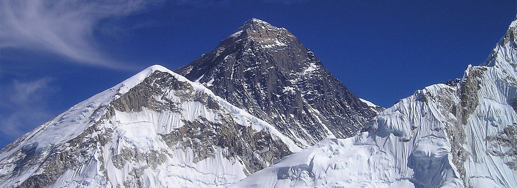
Mt. Everest (8,848 meters) is the highest mountain in the world. Located in the Khumbu region, Mt. Everest is also known as ‘Sagarmatha’ which means ‘Goddess of the Sky’. The Everest expedition requires a high degree of patience and commitment. Along with climbing Mount Everest, we will also get to explore Sagarmatha National Park.
Moreover, the highest national park in the world is home to diverse wildlife including Snow Leopard, Red Pandas, Musk Deer, Himalayan Tahr, and others. Everest Expedition is a once-in-a-lifetime opportunity to ascending the highest mountain peak in the world. You can also explore the high mountain valleys and alpine landscapes during the trek.
Mt. Everest Expedition starts with an adventurous flight towards Lukla from Kathmandu. From Lukla, we will start our trek along a well-defined trail that takes you through the settlements of the Everest region. The trail passes through Namche Bazaar, Tengboche, Dingboche, Lobuche, and Gorakshep, to finally arrive at Everest Base Camp.
Expedition Route
After arriving at Everest Base Camp, we will set our tents and acclimatize by going up and down in altitude. The approach towards the mountain is from its south side. We will pass through the infamous Khumbu icefall and Glacier extending down to Lobuche (4940m).
The South route is technically less challenging after you cross the Khumbu icefall. There are a few crevasses and seracs bridged by ladders and a couple of short ice cliffs around camp 3. There are few rock sections protected with fixed lines. The Khumbu Icefall is a steep glacier with large crevasses and a high danger of falling ice.
The Sherpa crew will set the route through the icefall by installing ladders across crevasses and along ice walls. These facilities make the Khumbu icefall possible, and relatively safe. Besides that, there are dangers of high altitude sickness and unpredictable weather conditions.
Camp 1 (6000m) is a desolate place used as a rest and transition location towards Camp 2 (6400m). The large crevasses close to camp 1 get fixed with ladders. Camp 2 at the bottom of the west ridge is safe with incredible views on Lhotse. Located in a lateral moraine, most climbers set up their main climbing camp with kitchen and dining tents. It is an acclimatization camp and the base for camp 3.
Camp 3 (7200m) is strategically located on a small ledge on the Lhotse wall. After crossing the glacier and climbing 40 deg. 600m on the snowfield you will arrive at Camp 3. There are 3m ice cliffs with fixed ropes along the route. Camp 4 (7950m) located at South Col is easily accessible without supplementary oxygen. There are two rock sections to navigate that is set up with fixed ropes.
Climb from Camp 4 to the summit is about 500m. This is one of the most dangerous parts of the climb as there are violent winds that can derail the expedition. We will use the narrow South-East Ridge to summit Mt. Everest.
- Elevation: 8,586m (28,169ft)
- Location: Nepal/Sikkim border
- Climbing Season: Late spring (more favorable) and autumn
- First Ascent: British Expedition, May 25, 1955
- Climbing Duration: Around 32 days
- Expedition Duration: Around 55 days
Mt. Kanchenjunga (8586m) is the second-highest mountain peak in Nepal and the third highest in the world. Located in the eastern region of Nepal, Mt. Kanchenjunga (8586m) has its name from two words 'Kanchen' and 'Dzonga' meaning "The Five Treasures of the Great Snows".
Kanchenjunga region is a remote area attracting few trekkers and thus retains its pristine beauty, and charm. Mt. Kanchenjunga is also considered a holy mountain by local Sikkimese people. 4 ridges radiate in an X pattern almost symmetrically from the main summit. Kanchenjunga is one of the most aesthetically beautiful mountains in the world.
The Kanchenjunga Conservation Area is home to the Red Panda and other rare and endangered animals. Kanchenjunga was widely believed to be the highest mountain in the world until 1852 when Mt. Everest was duly crowned as the highest mountain in the world. On May 25, 1955, Joe Brown and George Band, of a British expedition team climbed Kanchenjunga for the first time.
The climb of Kanchenjunga is technical and intricate as climbers need to pass through mixed rock and ice climb to the North Col. This gets followed by a steady 1500m ascent to the summit. The views of the entire Himalayan vista from the summit of the Kanchenjunga Expedition are stunning.
Expedition Route
The trek from Suketar to the Base camp is remote and exciting. The rare and endangered flora of the region includes 30 varieties of rhododendrons and 69 varieties of orchids. The North Face route is the safest, and easiest route for the Kanchenjunga Expedition.
Kanchenjunga Base Camp at 5,180 m is the base point for our expedition. Our Sherpa crew will fix lines up 900 m for intricate mixed climbing to the North col. It is the most challenging part of the expedition. After making our way towards the North Col, you can set up three camps up the North ridge. You can move higher up the mountain slowly in extreme weather to arrive at the summit.
- Elevation: 8,516m (27,940ft)
- Location: Nepal/Tibet border
- Climbing Season: Late spring
- First Ascent: Ernst Reiss and Fritz Luchsinger (Swiss), May 18, 1956
- Climbing Duration: Around 43 days
- Expedition duration: Around 64 days
Mt. Lhotse is a beautiful mountain and is part of the Everest massif. With an altitude of 8516m, it is the fourth highest mountain in the world. The three summits of Lhotse are the Lhotse main summit (8,516m), Lhotse Middle East (8,414m), and Lhotse Shar (8,383m).
Lhotse has the smallest prominence of only 610m, among all 8000m expeditions Nepal. Lhotse has a dramatic south face that rises 3.2km within a 2.25km horizontal distance. It makes the steepest mountain face on earth and is an extremely difficult climb. The South Face of Lhotse is hence rarely attempted.
The primary route to the summit of Mt. Lhotse is via Everest South Col. Swiss duo of F. Luchsinger and E.Reiss first climbed Lhotse in 1956 through the West Face. A Czech climber climbed the South Face of Mt. Lhotse only in 1984. Similarly, the Lhotse Shar summit got climbed for the first time on May 12, 1979, and the Lhotse middle on May 23, 2001.
Expedition Route
Climbers from South Col on Everest must overcome a 1,125m wall of glacial blue ice. This Lhotse face rises around 40-50 degree pitches and there are some occasional 80-degree bulges as well. The two rocky sections on the face are the Yellow Band and the Geneva Spur.
The Lhotse standard climbing route is the same as Everest's South Col route up to the Yellow Band. After the Yellow Band, Everest climbers take a left over the Geneva Spur up to the South Col. Whereas the Lhotse climbers take a right towards the Lhotse face. We have to pass through the narrow "Reiss couloir" to arrive at the summit of Mt. Lhotse.
- Elevation: 8,463m (26,747ft)
- Location: Makalu/Baruntse
- Climbing Season: Late spring (more favorable) and autumn
- First Ascent: Jean Couzy and Lionel Terray (French Expedition), 1955
- Climbing Duration: Around 31 days
- Expedition Duration: Around 50 days
Mount Makalu (8,463 m) is the fifth highest mountain in the world. The four-sided pyramid mountain lies about 19 kilometers southeast of Mount Everest in the Mahalangur region. Mt. Makalu requires crossing several technical sections with steep pitches and knife-edged ridges.
The summit pyramid also involves technical rock climbing. It is one of the most challenging expeditions in the world. Hence, climbers must have prior peak climbing experience and a basic level of fitness for the Makalu Expedition. Mt Makalu was first ascended on May 15, 1955, by Lionel Terray and Jean Couzy. They were a part of a French Expedition Team led by Jean Franco.
The awe-inspiring views of the entire Himalayan landscape from the summit of Makalu will make you forget all your struggles. You can observe the snow-capped mountains from Kanchenjunga in the East to Shishapangma in the West. Makalu Expedition will provide you with a great adventure while climbing the fifth highest mountain in the world.
Expedition Route
After arriving at the Makalu Base Camp after a trek of several days, we make our way to Advanced Base Camp. Located at a rocky dome (5,600 meters), it is our main camp for expeditions. From there, we climb a rocky moraine and arrive at a gentle angled glacier. We then climb a steep ice and snow wall with the help of fixed ropes before arriving at Camp One (6,300 meters).
From Camp One, we climb over a broad glacier to arrive at Camp Two (6,600 meters). The trail then gets long and steep to arrive at Camp Three or Makalu La located at an altitude of 7,500 meters. After crossing this hardest part of the climb we easily traverse to Camp Four at an elevation of 7,800 meters.
We then climb moderate glacial slopes to the French Couloir which is steep and involves crossing rock bands and a bit of snow climbing. After arriving at the top of the couloir, we climb a ridge on rock past the false summit to arrive at the summit of Mt. Makalu.
- Elevation: 8,201m (26,906ft)
- Location: Nepal/Tibet border, 30km west of Everest
- Climbing Season: Late spring and autumn
- First Ascent: Herbert Tichy (Italy), Joseph Joechler, and Pasang Dawa Lama (Nepal), October 19, 1954
- Climb duration: Around 23 days
- Expedition Duration: Around 41 days
Cho Oyu is one of the most popular 8000 meters mountain peaks. The sixth highest mountain in the world lies in the Nepal Tibet border, and around 70 kilometers away from Everest. Cho Oyu Expedition from the Tibet side is one of the most straightforward climbs with the highest rate of success among all 8000 meters mountains.
The normal route ascends from the northwest face on the Tibetan side of the Nangpa La, which is also the old trading route to Nepal. Cho Oyu climb is relatively non-technical however, you must have some mountaineering experience in 6000m peaks like Island, Mera, Lobuche, Chula, and others.
Some technical training using fixed lines to ascend and descend independently is also necessary. You also should know how to crampon on steep ice or snow slopes. Good physical condition and a basic level of fitness increase the chance of success.
Expedition Route
The Northwest Ridge or the Tichy Route is normally used for first-time climbers of 8000m peaks. You do not require any technical climbing skills and have a less than 50-degree snowfield along with a short section of yellow band rock with fixed lines. The route begins at the base of Peak or the Advanced Base Camp (ABC) at 5700m (18,700 ft).
The route then takes you to Camp 1 at 6400m (21,000 ft) after ascending for quite some time. Camp 1 is well sheltered by the ridge itself below the base of the Northwest ridge. From Camp 1, the route opens out onto the Northwest face where you have to cross a steeper 30-50m section with moderate ice cliffs.
Fixed ropes help unskilled mountaineers to cross from Camp 1 and 2. Camp 2 gets located at about 7200m. High camp gets fixed at about 7450m just below yellow bands to increase the chance of success on the summit day. Some strenuous climbing is necessary to fix the yellow bands with rope.
The expedition then continues this steep snowfield to the Northwest Ridge’s crest before finally arriving at the false summit. We then cross a broad plateau with a small rise to arrive at the true summit of 8201m (26,901 feet). The incredible views of the snow-capped mountains including Mt. Everest and Mt. Makalu will enchant you.
- Elevation: 8,167m (26,795ft)
- Location: Dhaulagiri Himal
- Climbing Season: Late spring (more favorable) and autumn
- First Ascent: Swiss-Australian team, May 13, 1960
- Climbing Duration: Around 29 days
- Expedition duration: Around 47 days
Mt. Dhaulagiri (8,167m) located in the Northwest of Myagdi District is the 7th highest mountain in the world. “Dhavala” in Sanskrit means “White” and “Giri” means “mountain peak”. The first successful summit was in 1960 from the Northeast ridge by the Swiss expedition team.
Dhaulagiri rises 7000m over Kali Gandaki valley with an incredible horizontal length of 30km. The majority of climbers ascend the mountain from the first ascent route. However, Dhaulagiri Expedition is possible from almost all directions. Dhaulagiri mountain peak has 5 ridges and two faces on the south and west side for climbing. It has routes from Swiss, Italian, and French camps as well.
More than 500 summit ascents have been successfully made until 2019. Due to its technically challenging routes, there is a lack of big commercial expeditions. However, the Dhaulagiri Expedition is one of the most attractive climbing destinations. Experienced mountaineers with prior experience in technical climbing can attempt this spectacular 8000m expedition in Nepal.
Expedition Route
Northeast Ridge is the most common route used in the Dhaulagiri expedition. It is also the original route used by the Swiss-Austrian expedition in 1960. There are 4 camps set up for climbing with Advance Base Camp at 5,300m. However, the camp is only used to deposit the gear and we don't stay overnight due to the risk of an avalanche.
Hence, the Dhaulagiri Base Camp (4750m) gets used for accommodation and meal purposes. Camp 1 will get set at 5,900m on the Col east from the ABC. There are risks of an avalanche as well as crevasses along the trail. We will arrive at Camp 2 (6,400m), after some steep climbing sections from Camp 1. You can learn the use of fixed ropes, ice ax, and technical climbing from your Sherpa crew.
We will arrive at Camp 3 (7400m) in the west with steep ice and snow climbing. You climb towards the East Ridge where you need to tackle strong wind conditions. From camp 3, we attempt to climb the summit and return to camp 3. We can also set up a bevy at 7,900m in case of difficult weather conditions and push for a summit the next day.
- Elevation: 8,163m (26,763ft)
- Location: Lamjung District, Manaslu Region, Nepal
- Climbing Season: Late spring (more favorable) and autumn
- First Ascent: Toshio Imanishi and Gyalzen Norbu (Japan), May 9, 1956
- Climbing Duration: Around 21 days
- Expedition Duration: Around 41 days
Mt. Manaslu (8163m), also known as Kutang is the world's eighth highest peak. Mansiri Himal range in the Gorkha district of Nepal is its location. “Manasa” means “Mountain of the Spirit” in Sanskrit. Located around 40 miles east of Mt. Annapurna, Mt. Manaslu has a prominence of 3092m. It looks like a wall of snow and ice hanging in the sky.
There are long ridges and valley glaciers that offer approaches from all directions. Manaslu region was only opened to trekkers only in 1991. However, there have been many unofficial trekking and mountain expeditions in the past. The Manaslu region remains restricted and remote. However, the access of helicopters for evacuation has assured the safety of trekkers and climbers in case of emergency.
Japanese expedition team made several attempts to climb the mountain between 1953 and 1956 and finally succeeded in 1956. This all-female Japanese team also made history with a woman climbing an over 8000m peak for the first time. Mt. Manaslu Expedition takes around 6 weeks to complete due to the long approach.
Expedition Route
The Manaslu expedition has many interesting routes available to arrive at a common summit. The original route used by the 1956 Japanese expedition up the Northeast face is also the standard common route. The climb is slightly more technical than Cho Oyu or Shishapangma. However, the low Base Camp increases the risk of avalanches.
There are 4 camps including C1 (5,500m), C2 (6,300m), C3 (6,700m), and C4 (7,300m) above the base camp. There are 100 meters vertical walls of 50-60 degrees between Camp-I and Camp-II. The route between Camp-I and -II has plenty of crevasses and icefalls. There is also a traverse beneath a majestic serac above the black rock wall.
The route between Camp-II and -III is a straight walk up to the col of Camp-III. There is a straight 30-40 degree climb of 400 meters in the route to Camp-IV. Finally, we cross another three big plateaus and ascend 100 meters to arrive at the summit ridge. From the summit ridge, it is a 60 meters straight climb to the summit.
- Elevation: 8,091m (26,545ft)
- Location: Annapurna Region, Nepal
- Climbing Season: Late spring and autumn
- First Ascent: Maurice Herzog (Nepal), June 3, 1950
- Climbing Duration: Around 24 days
- Expedition duration: Around 41 days
Annapurna I (8091m) is the 10th-highest mountain peak in the world. A French Expedition team led by Maurice Herzog summited the mountain peak on 3 June 1950. It was the first 8,000m peak to get climbed. It took 20 years for Chris Bonington's team to climb the summit from the South Face of Annapurna. This famous mountain peak is rarely climbed by mountaineers.
Annapurna means ‘Goddess of the Harvests’ in Sanskrit. In Hinduism, Annapurna is the mother goddess who feeds and prevents starvation. The entire massif falls under the Annapurna Conservation Area led by Project (ACAP). The famous Annapurna Circuit trek is another highlight of the region.
The South Face of Annapurna is one of the steepest mountain faces. It is 3000 feet higher than the southwest face of Mt. Everest which makes it quite challenging. However, the South Face has less risk of avalanches and other hazards as compared to the North Face of the mountain.
Expedition Route
We will arrive at the Advanced Base Camp (4190m) located at the North Annapurna Glacier after a 7-9 days trek. The West Face and Northwest Ridge of Annapurna is the standard route. It is a very challenging route and Annapurna is one of the most dangerous peaks above 8000m.
The sections between camps 1 and 2 are the most dangerous and difficult due to unstable and broken glaciers. It also has dangling Seracs ready to crash and danger of avalanches. There are a total of 3 camps. Climbers have to face a 70 deg steep 500m climb with fixed ropes to arrive at the bottom of the climb.
This section also requires using fixed ropes to cross 1000m. Switchbacks navigation is essential on the snowfield between Seracs of the broken glacier from Camp 2 to Camp 3. The ascent of the summit from Camp 3 gets done on an exposed ridge without the use of fixed ropes. The incredible views of the snow-capped mountains from the top of the summit are awe-inspiring.
The Final Say
Nepal has some of the most incredible mountains in the world including the highest of them all, Mt. Everest (8848m). The eight 8000m expeditions Nepal include Everest, Kangchenjunga, Lhotse, Makalu, Cho Oyu, Dhaulagiri, Manaslu, and Annapurna I. All of these mountains are available for expeditions.
These technical mountains are challenging for all climbers. Hence, mountaineering skill sets training before the expedition is essential. Well-qualified professional mountaineering guides will take you on a great mountaineering expedition. Overall, the 8000m expeditions Nepal is an adventure of a lifetime.
Need Help Planning an Expedition to Nepal?
We the members of Mount Mania, wish you a wonderful journey to the Himalayas, and feel free to contact us if you would like to organize the above expedition with a professional Sherpa expedition guide.